Mike, Looking at his old posts, I think that has been Bryan's position all along.
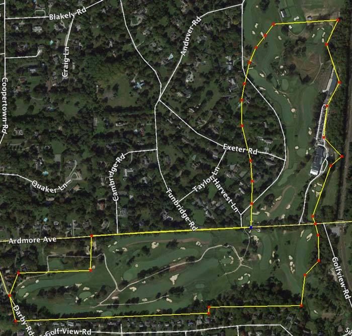
Francis described an area "about" 130x190 yards, the location of the 15th tee and 16th green. This roughly, but not exactly, describes the area between the Haverford College property and the road. A 130x190 yd. rectangle is 5.1 acres. So Merion swapped about 5 acres of land next to the Haverford College property for "land now covered by fine homes along Golf House road."
The white rectangle below is 130x190 yards and measures 5.1 acres. The orange rectangle also measures 5.1 acres. I am not suggesting that these represented exactly what was swapped because obviously they do not. But I do think they give a rough idea of the swap that Francis was describing.
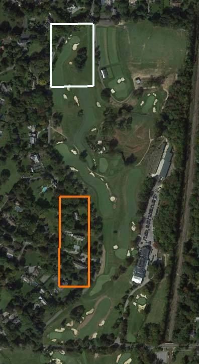
Apparently, prior to the swap, Merion was trying to fit the golf course on land which excluded the white triangle from consideration. The swap allowed them to use the area in the white triangle, and thus resolved a routing problem, but they gave up land across what is now Golf House road to get access to the land in the white triangle. I don't think it is any more complicated than that.
__________________________________
Also Mike, thanks for further demonstrating the extent of your reasoning powers in that last little flight of fancy. It is too idiotic to take seriously, and this includes your strange conjecture that the quarry could only be approached from the north. So much for the 17th hole!
David,
If that's Bryan's theory then I'm really not sure how it makes more sense to include a 5.1 acre rectangle than a 4.8 acre semi-triangle which is what's there in actuality?
Your drawing indicates much of that rectangle crossing the boundary across Golf House Road into the neighboring estates. "Most", or "close" only counts in horse shoes, not real estate transactions.
Regarding my "idiotic" contention that the quarry could only be reasonably approached from the north, of course one could stand on the edge of the quarry cliff and play down into it on a par three as they do on 17 today. That's hardly "approaching" the quarry but instead standing atop the ledge.
But instead of me responding to your continual and ineffectual insults, I'm feeling like I'm again channeling the original Committee participants...aaarrgggghhh...
Mr. Francis: Mr Lloyd, we have a problem.
Mr Lloyd: And what would that be my dear Mr. Francis?
Mr. Francis: You know that land that Mr. Macdonald told you and Mr. Griscom would be suitable for 18 good holes? Well, I've been pouring over maps and...well...you know how he told you that the quarry can be made much of? Well, I've been trying to make much of it and not much is happening but I'll keep trying much more.
Mr. Lloyd: For heaven's sake man, calm down...what do you mean?
Mr. Francis: Well, for starter's the quarry is fricking HUGE! I mean, it's 250 yards wide and 150 yards long! And it's deep with a steep cliff wall on two sides so I can't come at it from the west or the south. And the east side is more land owned by the railroad and we really don't want to deal with those bastards again right?
Mr. Lloyd: I won't have you using that type of profanity in my house. Why some of those railroad robber baron...er...railroad officials are among the finest upstanding citizens of this community. And afterall, they did help you locate those first 13 holes by leasing us those 3 acres if you recall.
Mr. Francis: (frustrated) I know, I know...I'm sorry.
Mr. Lloyd: Tut tut, there now my good man.
Mr. Francis: Ok, so back to the problem. Our problem. We've got those 13 holes and then we go north with 14. I'm envisioning a big, uphill, challenging par four that will set the stage for an amazing finish. And then...
Mr. Lloyd: And then??
Mr. Francis: Nothing.
Mr. Lloyd: Nothing?
Mr. Francis: Nope. Nothing but quarry. Oh, you guys left me 150 yards to the left of it and a hefty 80 yards beyond it...thanks for nothing!
Mr. Lloyd: But surely that young whippersnapper Mr. Wilson can help solve this problem?
Mr. Francis: Who? That guy? Is he still a member? Oh, that's right....But he won't even be appointed to head a Committee for months yet, and he's a Princeton fellow don't you know, so I have my doubts.
Mr. Lloyd: True Dat.
Mr. Francis: So here's what I'm thinking. We get the 14th green up near that quarry wall and then for the next hole we can stand right on the edge and play to a par three on the quarry floor below. But then how do we get down there?
Mr. Lloyd: I'll have my workmen build a large spiral staircase down into the depths! Problem solved!
Mr. Francis: Ok, now we're cooking with kerosene! Then, we need to get out so I'm thinking another par three in the opposite direction to the top of the quarry cliff wall for 16. Kinda blind, but we can call it an Alps or something that will keep Macdonald happy.
Mr. Lloyd: Will that require an additional staircase?
Mr. Francis: Perhaps. But I still have two holes left. Would it be considered gauche by future GCA afficianados to have three par threes in a row?
Mr. Lloyd: Some of them might think it's cool because it breaks the rules. I can see that Naccarato guy asking for the distance to the quarry wall, just to watch his tee ball deflect back at him at 200 mph!

Mr. Francis: Ok, then we go with the three par threes in a row. That will make Mr. Macdonald pleased i'd imagine as we would be certainly making much of the quarry! But then...
Mr. Lloyd: Spit it out Francis!
Mr. Francis: But then we still need to get back to the clubhouse and my 17th hole ends down in the depths of the quarry. Do you think Mrs. Biddle and the other members will like to finish with a 200 yard carry out of the quarry and a long downhill run to the green?
Mr. Lloyd: Probably not, but too many members are taking up the game anyways. That finish you describe ought to discourage a good number of them!
Mr. Francis: Yes sir.. I knew we could solve this problem. By the way, how did Wilson get that plum future committee assignment? We do all the work and I just have this sinking feeling that history is going to give him all the credit.
Mr. Lloyd: He has pictures.