News:

This discussion group is best enjoyed using Google Chrome, Firefox or Safari.


Patrick_Mucci

Re: Was C.B. Macdonald's routing of NGLA
« Reply #575 on: May 22, 2015, 08:30:24 AM »
Mike you keep saying it was "down to the exact acreage" but 205 does not equal 200.

Nor does it equal 165...


Pat,

Why did CBM say they still needed to figure a lot of it out over the next several months?

Where did he say that ?

But, let me answer for you.

If you've read "Scotland's Gift" you begin to realize that CBM never stopped designing/tinkering with the golf course for 20 years after inception.

He changed yardages by moving tees, he added and changed bunkers and I would imagine had to figure out which green contours he wished to introduce.


Patrick_Mucci

Re: Was C.B. Macdonald's routing of NGLA
« Reply #576 on: May 22, 2015, 08:39:09 AM »
Pat,

I understand and largely agree how all of those things ultimately determined the routing.

But you're still talking about the golf course as it became by sometime in 1907, not what was envisioned in late 1906 when CBM secured 205 acres consistent with his agreement with the Founding members down to the exact acreage.  Over the next five or so months, that all changed.

Mike,

I think you're forgetting that CBM told you that he routed the course first, then placed the holes he desired on the sites he deemed appropriate.
One could also state that he found the location for the holes he wanted and that process then determined the routing.
But, it's clear, he had designed the course on paper and only needed to acquire the land to fulfill his dream

CBM states: "The Company agreed to sell us 205 acres, AND WE WERE PERMITTED TO LOCATE IT AS BEST TO SERVE OUR PURPOSES.

                  Again, we studied the contours earnestly,
                  SELECTING THOSE THAT WOULD FIT IN NATURALLY WITH THE VARIOUS CLASSICAL
                  HOLES I HAD IN MIND,

                  AFTER WHICH WE STAKED OUT THE LAND WE WANTED.


Subsequent to that, he optioned the land he had staked out..

So, the minute CBM staked out the land he wanted, the routing had been determined.

I don't know why you're having such a difficult time understanding that ?


« Last Edit: May 22, 2015, 08:50:25 AM by Patrick_Mucci »

JESII

  • Karma: +0/-0
Re: Was C.B. Macdonald's routing of NGLA
« Reply #577 on: May 22, 2015, 08:43:22 AM »
Here, among other similar quotes.


I agree that he knew he would fit his course in the land optioned...and that he had located several holes but that's a long way from the routing being set in stone. The acreage to purchase, yes...the hole concepts, no.

How many of the green sites do you think he had located prior to optioning the land? Other than the four or five referenced directly, are there any others?

Patrick_Mucci

Re: Was C.B. Macdonald's routing of NGLA
« Reply #578 on: May 22, 2015, 09:05:38 AM »
Here, among other similar quotes.


I agree that he knew he would fit his course in the land optioned...and that he had located several holes but that's a long way from the routing being set in stone. The acreage to purchase, yes...the hole concepts, no.

Jim,

Another newspaper article ?  ?  ?

Versus "Scotland's Gift"  ?

You did read the portion of the article that referenced distances, didn't you.

The article is in direct conflict with CBM's written words in "Scotland's Gift", where he stated, in advance, what holes he wished to introduce.
He had decided on the holes and their location long before a committee would meet to decide which holes and where.  
A committee which was basically non-existant and probably for promotional purposes early in the project.
Several holes ?

It was the entirety of his hole concepts that was the basis for creating this course.

He stated that his intent was to reproduce the various classical holes he had in mind.
He had them in mind PRIOR to inspecting the property.
He had them in mind when he studied the property.
He had them in mind when he located the sites and optioned the property.
Reread "Scotland's Gift"
[/size]

How many of the green sites do you think he had located prior to optioning the land?

My guess, in terms of the general area................ 18
[/size]

Other than the four or five referenced directly, are there any others?

Yes,
Please read chapter IX "Inception of Ideal Golf Course"

I think it will provide some insight relative to the holes he had in mind before optioning the land.

But, ask yourself this question.

If he studied the land and could pick any 205 of the 450 acres, and he stated that after studying the land he selected the land that would fit in naturally with the various classical holes he had in mind, and then he staked out the entire parcel he wanted, do you think he only had four or five holes in mind, when he staked out the land, as you stated ?

Or, do you think he had his full compliment in mind, knew where the holes were going to be, and then staked out the land that would accomodate all of them ?

« Last Edit: May 22, 2015, 09:13:01 AM by Patrick_Mucci »

JESII

  • Karma: +0/-0
Re: Was C.B. Macdonald's routing of NGLA
« Reply #579 on: May 22, 2015, 09:09:32 AM »
I think he knew he could build his ideal course there, as he said, but he explicitly says..."distances and the holes to be reproduced will be decided upon by the committee in the next five months"...not the prior five months.

It sounds like he had well more than 18 hole concepts in mind and wanted to see which concepts best fit on the land there?

Patrick_Mucci

Re: Was C.B. Macdonald's routing of NGLA
« Reply #580 on: May 22, 2015, 09:17:47 AM »

I think he knew he could build his ideal course there, as he said, but he explicitly says..."distances and the holes to be reproduced will be decided upon by the committee in the next five months"...not the prior five months.

Jim,

You keep ignoring CBM's written words in "Scotland's Gift" where he told you the holes and their location PRIOR to staking out and optioning the land.

Why do you keep dismissing that fact.

And, it wasn't four or five holes, he named six at a minimum.


It sounds like he had well more than 18 hole concepts in mind and wanted to see which concepts best fit on the land there?

And, he knew that before he optioned the land.

Why would you search for "template" holes, study the land to see where they would fit in naturally and then buy land that you didn't know could accomodate them ?


JESII

  • Karma: +0/-0
Re: Was C.B. Macdonald's routing of NGLA
« Reply #581 on: May 22, 2015, 09:28:25 AM »
Pat,

I can appreciate what he said in 1912, and don't think it was disingenuous, but I'll take his words in December 1906 as more accurate for his state of mind at the time. Kind of self evident, don't you think?

Patrick_Mucci

Re: Was C.B. Macdonald's routing of NGLA
« Reply #582 on: May 22, 2015, 09:36:02 AM »
Pat,

I can appreciate what he said in 1912, and don't think it was disingenuous, but I'll take his words in December 1906 as more accurate for his state of mind at the time. Kind of self evident, don't you think?

How do you know that those were his words in December 1906 ?

Reread what Rich Goodale stated about "Newspaper" articles.

In December of 1906 he had already found the holes he wanted and staked out the land accordingly.

Why else do you think he would have selected that specific and unique 205 acres from the available 450 acres ?


JESII

  • Karma: +0/-0
Re: Was C.B. Macdonald's routing of NGLA
« Reply #583 on: May 22, 2015, 09:42:23 AM »
Because the features he did have dictated such...no point in making it more complicated than that.

Patrick_Mucci

Re: Was C.B. Macdonald's routing of NGLA
« Reply #584 on: May 22, 2015, 09:45:13 AM »

Because the features he did have dictated such...no point in making it more complicated than that.

Then you're in agreement, he sited his holes on the land he had studied, first, then optioned the land where those holes were to be located, YES ?

Patrick_Mucci

Re: Was C.B. Macdonald's routing of NGLA
« Reply #585 on: May 22, 2015, 09:49:12 AM »
Jim,

Which do you believe is better land for golf, holes 9 & 10 at NGLA or the land now comprised of the clubhouse, parking lot, 10th, 17th and 18th holes at Sebonack ?

Swamps and bogs or high land overlooking Peconic Bay, absent swamps and bogs ?

Bryan Izatt

  • Karma: +0/-0
Re: Was C.B. Macdonald's routing of NGLA
« Reply #586 on: May 22, 2015, 10:00:55 AM »
This stuff is not easy to do.  Metes and bounds of deeds is probably the most exact way, but even that is difficult with the tools we have available.  Finding deed metes and bounds starting points that were relevant in the early 1900's is not so easy now.

Assuming the county's acreages are right and the property outlines are about right, the two main properties are 237 acres.  CBM supposedly bought 205.  Where the heck are those extra 32 acres.  The current property outline doesn't look much different than the early map we've looked at many times and assumed that it defined the boundaries.  Whatever variances we see don't seem to add up to 32 acres.

First, while I think the metes will help us understand the western border, I doubt deeds will be much help with the eastern border.  My guess is that the deeds describe the boundary ("bound") as  Bullshead Bay and the Peconic.  Generally (depending on navigability and on the jurisdiction) this would mean that he owned up to the high water line.  Looking at the blueprint, the eastern boundary is very different today than it was in 1906. 

This also may also start to explain from where the 32 came. Take the 12 acre triangle at the northwest corner for example.  On the 1904 map that is almost all water.  So it may not have been part of the 32 acres.  And a substantial bit along the eastern border was swampy.  This gets us part of the way there.


David, 

At least half the eastern border is next to land.  The deeds should help with that and the southern border too.  Knowing the eastern boundary would have helped SHGC recently when they built their new back tee on NGLA property.

Agreed about the triangle in the northwest corner.

Still some way to go in figuring out the differences.


JESII

  • Karma: +0/-0
Re: Was C.B. Macdonald's routing of NGLA
« Reply #587 on: May 22, 2015, 10:04:21 AM »
Pat,

The general timeline isn't really in debate; he studied the whole area and located a handful of essential features to exploit, optioned the land that encompassed those features and enough for the rest of the course with the confidence he could build the rest of his course based on what he saw, then built the holes.

As to the quality of the land, clearly he saw more value in access to the Southampton Inn and roadways than the high land now used by Sebonack GC. Again, this is self-evident.

MCirba

  • Karma: +0/-0
Re: Was C.B. Macdonald's routing of NGLA
« Reply #588 on: May 22, 2015, 10:35:00 AM »
Pat,

I can appreciate what he said in 1912, and don't think it was disingenuous, but I'll take his words in December 1906 as more accurate for his state of mind at the time. Kind of self evident, don't you think?

Jim,

I believe "Scotland's Gift" was written in 1928, over two decades after the events in question.   

And yes, I believe CBM accurately represented events in that book but believe that Pat and David are mis-interpreting it slightly, which I'll get to shortly.

"Persistence and determination alone are omnipotent" - Calvin Coolidge

https://cobbscreek.org/

MCirba

  • Karma: +0/-0
Re: Was C.B. Macdonald's routing of NGLA
« Reply #589 on: May 22, 2015, 10:50:06 AM »

Also keep in mind that at some point CBM owned 20 acres adjacent to the west of his 8th and 9th hole which he sold to Charles Sabin in 1920.  I'm not sure where that fits in the puzzle.


Mike, 

I'm not convinced that that's where the 20 acres was.  It could have been part of Ballyshear or some other property we don't know of.


Bryan,

From this snippet, we know it wasn't Ballyshear as that is not south of Sebonac Road.   We also know that he's "adding" a farm to his larger estate, which is the area he had purchased around 1917 that included over 300 acres, much of what is today Sebonack Golf Club.

I don't think that leaves a lot of room for interpretation, do you?
"Persistence and determination alone are omnipotent" - Calvin Coolidge

https://cobbscreek.org/

Bryan Izatt

  • Karma: +0/-0
Re: Was C.B. Macdonald's routing of NGLA
« Reply #590 on: May 22, 2015, 11:05:20 AM »


Patrick,

So, the sun is a problem in March, but the course is closed.  Then it's a problem in September too.  Is the course closed then too?

As for the topography, I have no interest in playing guessing games with you.  If you have something informative to add, please do.  If not, don't.


Bryan Izatt

  • Karma: +0/-0
Re: Was C.B. Macdonald's routing of NGLA
« Reply #591 on: May 22, 2015, 11:11:42 AM »
Mike,

Fair enough.  It's not part of Ballyshear.  Deeds would be helpful.


Also keep in mind that at some point CBM owned 20 acres adjacent to the west of his 8th and 9th hole which he sold to Charles Sabin in 1920.  I'm not sure where that fits in the puzzle.


Mike, 

I'm not convinced that that's where the 20 acres was.  It could have been part of Ballyshear or some other property we don't know of.


Bryan,

From this snippet, we know it wasn't Ballyshear as that is not south of Sebonac Road.   We also know that he's "adding" a farm to his larger estate, which is the area he had purchased around 1917 that included over 300 acres, much of what is today Sebonack Golf Club.

I don't think that leaves a lot of room for interpretation, do you?

Bryan Izatt

  • Karma: +0/-0
Re: Was C.B. Macdonald's routing of NGLA
« Reply #592 on: May 22, 2015, 11:24:50 AM »

Patrick,

I'm only loosely following your debate with Jim and Mike's and David's but I was struck by your comment:

Quote
I think you're forgetting that CBM told you that he routed the course first, then placed the holes he desired on the sites he deemed appropriate.

Could you provide the quote from Scotland's Gift for that.  What do you (he) mean he routed the course first, if he then subsequently placed the holes on the site after the routing was done.  If he didn't know what holes and where they were located  on the property for all 18 holes, how did he route the course.  Don't you require greens, tees, and lengths of 18 holes to do a routing?

If he said he had sites for 6 holes early on (on the 2 or 3 days on horseback), do you think that meant he knew the green site, the tee site, the hole length and the configuration of the hole at that moment.  When, approximately, did he say that he figured out the  green site, the tee site, the hole length and the configuration of the hole for the other 12.


MCirba

  • Karma: +0/-0
Re: Was C.B. Macdonald's routing of NGLA
« Reply #593 on: May 22, 2015, 02:48:57 PM »
There is neither a "problem" nor a "glaring error" with my summary of CBM's chronology of events from Scotland's Gift. And he was writing a narrative which included a chronology of events.

In contrast, your chronology flip-flops events in an way that CBM obviously did not intend, and in a way which directly contradicts the December news accounts. For example, read this excerpt from CBM:
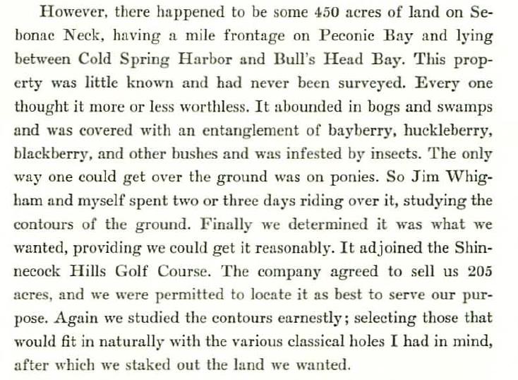
. . . So Jim Whigham and myself spent two or three days riding over it, studying the contours of the ground.  Finally we determined what it was we wanted, providing we could get it reasonably.  It joined Shinnecock Hills Golf Course.   The company agreed to sell us 205 acres, and we were permitted to locate it as to best serve our purpose. Again, we studied the contours earnestly; selecting those that would fit in naturally with the various classical holes I had in mind, after which we staked out the land we wanted.
We found an Alps; found an ideal Redan; then we discovered a place we could put the Eden hole which would not permit a topped ball to run-up on the green.  Then we found a wonderful water-hole, now the Cape.


Let me ask you . . .  By CBM's account, which event happened first:
     "The company agreed to sell us 205 acres, and we were permitted to locate it as to best serve our purpose."
OR
     "Again, we studied the contours earnestly; selecting those that would fit in naturally with the various classical holes I had in mind, after which we staked out the land we wanted.  
We found an Alps; found an ideal Redan; then we discovered a place we could put the Eden hole which would not permit a topped ball to run-up on the green.  Then we found a wonderful water-hole, now the Cape. . . ."


The answer is obvious, and it doesn't match your chronology.
___________________________________________________________

As for your claim that I made a "glaring error" about the date they first staked out the land they wanted, I disagree.  By mid-December CBM had already chosen roughly 205 acres from among the 450 acres, and he provided a detailed physical description of the that parcel he intended to purchase. That would have been pretty hard to do had he not staked it out first.  

CBM did say that the "exact lines" would not be staked out until the plans were complete, but so what?  Do you really think the developer is going to sell an option without the land having been at least roughly marked off to show both parties the subject of the transaction?


David,

If I might, I prefer to answer your last question first and I think the answer is “Yes”, I do think the developer provided Macdonald with an “option” for 200 of the roughly 450 acres available on Sebonac Neck without the land being staked off.

Remember that CBM told us that, “the land had never been surveyed and every one thought it was more or less worthless”.   We know that land wasn’t in the developer’s real estate plan that spanned thousands of acres that had been surveyed by Olmstead and Vaux.   We also know that the first 120 acre site “near the (Shinneock) canal” that Macdonald wanted and the developer rejected was right smack dab in those development plans that were created in 1906.

Macdonald also told us that Sebonac Neck was so overgrown and bug-infested that it could only be traversed by horseback.   I have to ask exactly how that staking would take place on such a property, because almost assuredly it hadn’t been cleared prior…who would have provided funding for such an effort that we also know from other sources didn’t take place until 1907.  

So I would envision that if we were to find the written terms of that agreement it would likely refer to the 200 acres in general terms, from the Shinnecock Hills Golf Course along the natural eastern boundary of the property out to the Peconic Bay.   Perhaps something like this;

“We have a stretch at our disposal of four acres in width and two miles long.   The exact lines will not be staked out until the committee has finished its plans, for latitude has been given to us in this respect as all concerned want the course to be ideal.  Bullshead Bay will be skirted for about a mile…”

Now I think we previously decided that Macdonald meant that an acre wide was 208.71 feet (time 4 acres for roughly 835 feet or 278 yards) and if we take that and multiply it by the 10,560 feet of two miles we get just slightly over 200 acres in total.   Now, both are slightly off in the sense that the course wasn’t quite as long as 2 miles, even if we travel as the golfer does and not as the crow flies, and we know the width eventually varied widely across the property from over 450 yards wide in spots to areas under 200 yards.   But still, CBM was describing what I would best describe as a “container”, a land parcel that included all of the natural features he and Whigham found on horseback and certainly more than enough land to build a golf course by his previous estimates.

So viewed in this light, it puts the timeline you describe in a completely different context.  


Macdonald tells us the property was little known and had never been surveyed.   He also tells us it was remote, it was overgrown, it was bug-infested, and yes, everyone thought it essentially worthless (presumably for farming or real estate).   He describes riding on horseback and determined that they wanted it IF they could get it for a decent price.   Remember, they had previously been rebuffed on their first attempt to buy land from this developer although the developer saw value in their National golf course being located nearby, no question.  

Before I go on, perhaps it is now the best time to go back in time a few months to the spring of that same year, 1906.   CBM and Walter Travis have been communicating back and forth via letter as Macdonald is in Europe getting drawings of the famous holes, over 30 of them.  
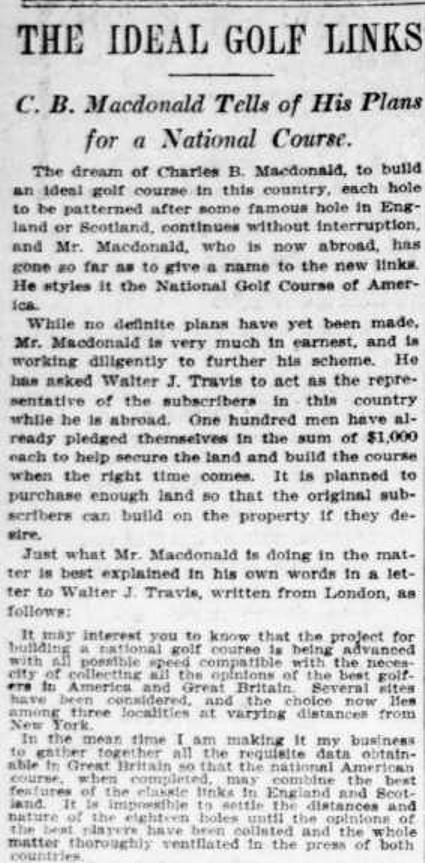
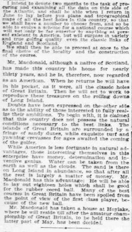


It’s clear from this report from March 24th, 1906 that the real estate component is still in Macdonald’s plans for his new club.   But how could this be?   Didn’t CBM say that he made his original offer to the developer a few weeks after the real estate company purchased the land??  Actually, no he didn’t and that’s another misunderstanding we have.   What he wrote was, “The Shinnecock Hills property, some 2000 acres, had been owned by a London syndicate and was sold at about $50 an acre to a Brooklyn company a few weeks before I determined that we should build a course there if we could secure the land.”

This was in late 1905, but what was the next thing this eager buyer did?   He planned a several months long trip abroad to study golf holes and get/make drawings of them in the spring of 1906!

The March report tells us that three Long Island sites were under consideration.   I think we can safely assume that the Canal site was one of them.   Other reports had him looking near Montauk.   Do I think CBM had already made an offer at that time for the Canal site.   No, I don’t think there’s any evidence of that at all; instead what CBM said is that a few weeks after the purchase he determined to build a course in the Shinnecock Hills if he could secure the land.

Which leads me to the question; why would Macdonald even mention a failed attempt to purchase land in his book over 20 years after the fact?   I think the reason is that it was directly related to him finding the Sebonac Neck site in the first place.   It’s not tough to envision a scenario where CBM makes an offer to buy the 120 acres of land near the Canal, the owner tell him that’s primo real estate, but suggests some remote, overgrown land under their control that isn’t planned to be developed for housing out on Sebonac Neck.   With that,  Macdonald and Whigham go for their rides, find the landforms and soils they were hoping for, and in November of 1906 they secure the right to purchase whatever 200 acres up there eventually suits their fancy for the golf course.

Macdonald signs the papers on December 14th 1906 and it’s reported in the press that weekend.   All the NYC news reports mention the real estate component for the Founders and neither the Real Estate company nor Macdonald blanch at that plan, much less rebut it.  

The reports announce Macdonald’s plans to use the next five months to select which holes to use, determine the yardages, plan the holes in detail, after which they will stake out the final routing and course boundaries and complete the purchase.   That work is completed as planned and in May of 1907 Mortimer S. Payne is hired to supervise the imminent construction.  

It’s interesting that you recently noted that you don’t think CBM routed from a topographic survey and I don’t think so either.   In fact, I think he hired Raynor that spring to first survey the boundaries as they were determined and then to create a topographical map to compare to his overseas drawings and therefore guide construction.   Here’s how CBM referred to Raynor’s work there;  ”Employing him to survey our Sebonac Neck property I was so much impressed with his dependability and seriousness I had him make a contour map and later gave him my surveyor’s maps which I had brought from Scotland and England, telling him that I wanted those holes laid out faithfully to those maps.”  Notice the "our" suggesting it was already purchased or at least secured by then.

 After securing the land in December of 1906 (i.e. “The company agreed to sell us 205 acres and we were permitted to locate it as best to serve our purpose”, almost exactly what Macdonald is quoted in December 15th news reports), CBM wrote; “Again, (as in, for the second time) we studied the contours earnestly; selecting those that would fit in naturally with the various classical holes we had in mind, after which we staked out the land we wanted.”

In his next paragraph, Macdonald tells us more about the property they found and some of the natural landforms to accommodate his redan, an Alps, a place with a water carry for his version of an Eden.   And yes, these were all found prior to December 1906 during his rides around the property with Whigham (interesting that he doesn’t name Travis who later claimed to be part of that activity, but that’s a discussion for another day.)

Then, almost as an after-thought, or perhaps remembering the differences between the accessibility, planned surrounds, and purpose of the two different sites, he writes; ”The property was more or less remote, three miles from Southampton, where thoroughfares and railroads would never bother us – a much desired situation.   When playing golf you want to be alone with Nature.”

In the next paragraph CBM tells us more about the timing of events; "We obtained an option on the property in November 1906 and took title to the property in the spring of 1907.   Immediately we commenced development.”

So, I hope you’ll understand that our respective interpretations of what CBM wrote are different and as such, the two questions you asked above are not relevant based on my interpretation which I’ve just described.   I don’t think Macdonald’s description of events followed in complete chronological order and his written thoughts bounced around a bit.   Also, let’s please avoid subsequent discussion on the October news reports about him sending survey maps to those overseas because I think I can show pretty easily that those reports didn’t understand what was being shared back and forth, a discussion on which holes were in fact Ideal, as well as CBM receiving topos and related drawings from his friends of some of those famous holes.

Finally, I know you asked some additional questions related to the value of the property which I’d simply answer this way.   The developer clearly thought having Macdonald’s National golf course near his development would be a boon to his real estate which is why he went to the additional expense of building the Shinnecock Inn and providing CBM “latitude” over several months to determine the final boundaries of his purchase.   However, somewhat ironically, it never worked, very little was ever sold and perhaps the entire failed financial fate of the Real Estate company was writ when they rejected CBM’s initial offer near the Shinnecock Canal.   For however adjacent or proximate the development came to Sebonac Neck, it evidently wasn’t close enough for the vast majority of club members to ever purchase lots.

I hope that helps explain my position.   Thanks.


« Last Edit: May 22, 2015, 03:27:23 PM by MCirba »
"Persistence and determination alone are omnipotent" - Calvin Coolidge

https://cobbscreek.org/

Patrick_Mucci

Re: Was C.B. Macdonald's routing of NGLA
« Reply #594 on: May 22, 2015, 02:57:29 PM »

Patrick,

So, the sun is a problem in March, but the course is closed. 

NO, for two reasons.
1     The topography
2     Nobody plays

I was just providing you with some information that you might find relevant.


Then it's a problem in September too. 

No, it's not a problem in September, or October.
Having played 72 holes in one day in October I think I'm reasonably qualified to make that statement.


Is the course closed then too?

No, but, it closes shortly thereafter


As for the topography, I have no interest in playing guessing games with you. 

But, you provided that great topo, so I thought that you would understand.

The rising land form on 18 blocks the setting sun.

On # 1, your target fairway is well below the tee, hence you're not looking at the horizon, but, down, to the fairway well below the elevated tee.


If you have something informative to add, please do.  If not, don't.

Perhaps, with the above revelations, you'll begin to understand that sometimes you actually have to examine the property in person to understand its function.


Sven Nilsen

  • Karma: +0/-0
Re: Was C.B. Macdonald's routing of NGLA
« Reply #595 on: May 22, 2015, 03:46:46 PM »
If the land was little known and had never been surveyed, how did they figure out the contour lines for this 1904 Map:


Someone, other than the seaweed collectors, must have been out on the property.

Is it any coincidence that the land that was purchased almost completely tracks the old path/road leading out to Peconic Bay?
"As much as we have learned about the history of golf architecture in the last ten plus years, I'm convinced we have only scratched the surface."  A GCA Poster

"There's the golf hole; play it any way you please." Donald Ross

Sven Nilsen

  • Karma: +0/-0
Re: Was C.B. Macdonald's routing of NGLA
« Reply #596 on: May 22, 2015, 04:01:53 PM »
My suspicion (admitted conjecture) is that it was easier to get around the parcel than CBM let on.  I also suspect that they used horses as it would have been the most expedient way to see the land.  They had a lot of ground to cover.

For all we know, CBM got out to the high point above Peconic Bay and envisioned exactly what he ended up building later, that is an out and back routing tracking the road they had just followed, with an idyllic setting away from the main thoroughfares and out of the shadow of Shinnecock.  

Sven
"As much as we have learned about the history of golf architecture in the last ten plus years, I'm convinced we have only scratched the surface."  A GCA Poster

"There's the golf hole; play it any way you please." Donald Ross

MCirba

  • Karma: +0/-0
Re: Was C.B. Macdonald's routing of NGLA
« Reply #597 on: May 22, 2015, 04:03:24 PM »
Sven,

It's a fair question, and I've speculated that perhaps Macdonald meant it had never been surveyed for real estate purposes?   Certainly it was never part of the Olmsted/Vaux real estate survey done in 1906.  

Or, from a golf perspective, those 10 foot intervals on that map aren't detailed enough for golf construction purposes so perhaps that's what CBM meant?

Also, I think one limiting factor was the need to use the Shinnecock Inn as a clubhouse so if you think about that reality as their starting and ending points it's really not that surprising that they went along that route.   The condition of that road was well-described by Darwin, though, so I don't think they went that way because a rutted sand path already existed.  
"Persistence and determination alone are omnipotent" - Calvin Coolidge

https://cobbscreek.org/

Sven Nilsen

  • Karma: +0/-0
Re: Was C.B. Macdonald's routing of NGLA
« Reply #598 on: May 22, 2015, 04:41:58 PM »
Well, those 10 foot intervals probably weren't specific enough for him to use for the plaster model he was going to have built for investor purposes.

As for the starting and ending points, I don't think he ever intended the Inn to be the permanent fix for the clubhouse. 

If you were in his shoes, where would you site a clubhouse on that 4 acre by 2 mile stretch, assuming you could eliminate from the discussion all of the logistical issues present at the start of the enterprise?

Sven
"As much as we have learned about the history of golf architecture in the last ten plus years, I'm convinced we have only scratched the surface."  A GCA Poster

"There's the golf hole; play it any way you please." Donald Ross

MCirba

  • Karma: +0/-0
Re: Was C.B. Macdonald's routing of NGLA
« Reply #599 on: May 22, 2015, 06:11:23 PM »
Oh...I get that Sven and I agree but the reason I call it a routing limitation is because he didn't have that option from the start so his beginning and ending spot was pretty well predetermined.  I think even Pat would agree that if he had his choice of any of the land within four hundred fifty acres he probably would have gone up into where Sebonack golf course is today but he didn't have that choice.
"Persistence and determination alone are omnipotent" - Calvin Coolidge

https://cobbscreek.org/

Tags:
Tags:

An Error Has Occurred!

Call to undefined function theme_linktree()
Back