News:

This discussion group is best enjoyed using Google Chrome, Firefox or Safari.


Bryan Izatt

  • Karma: +0/-0
The Pine Valley Deeds
« on: November 07, 2011, 11:35:08 AM »
I have recently come into possession of copies of some early deeds for Pine Valley.  Following is a summary of the first few, with the remainder to follow as time permits.

________________________________________________________________________________________________________

On May 31, 1904 Joseph S Kratz and Ida L Fentin as executors of the estate of Jonas Bowman sold the 184.31 acres that would become the core of Pine Valley to the Lumberton Sand Company.  The selling price was $3593.40.

The sale reserved and excepted therefrom a certain right of way to and from Sumner Station on the Narrow Gauge Railroad.  The right of way was 10 feet wide and started at the northwest corner of the property and followed the northern boundary of the property and then followed the railway boundary south to the station.

The sale also reserved and excepted a certain tract of land of about 160 acres.  The tract of land appears to abut the 184 acres on the southwest side.  The implication is that Bowman had originally owned a single larger tract and his executors sold off the 184.31 acre subset of the larger property to Lumberton.

The metes and bounds of the property are according to a survey made by Pires M Sperchers, a surveyor, on November 16, 1901.

_______________________________________________________________________________________________________

As a slight tangent from the Pine Valley deeds, George A. Crump, along with his sisters Helen and Elizabeth, and his brother Ralph inherited an almost 2 acre property from their mother upon her death, who in turn had inherited it upon her husband’s death.  The property was located near the intersection of Maple Terrace and Locust Streets in Merchantville, NJ.  On April 19, 1912 George A. Crump bought out his sisters’ (and their respective husbands) share of the family property for $1 (and no other valuable considerations).

________________________________________________________________________________________________________

On October 30, 1912 George A. Crump bought from the Lumberton Sand Company the 184.31 acre property that Lumberton had bought from the estate of Jonas Bowman in 1904.  The metes and bounds of the property are exactly the same as those from the earlier sale.  The selling price was $8,750.  There were no other valuable considerations.

The deed contains the same exception as did the Lumberton purchase of 1904 – namely that there was a right of way, ten feet wide from the northwest corner of the property, across the northern boundary and then southward to the Sumner train station.

This deed also had a reservation.  The reservation required that, for 20 years, Crump not sell any sand or gravel from the site.  It also required that he not allow any sand or gravel to be hauled over the site for the purpose of sale.  An exception was allowed for hauling over any public road on the property or along the right of way mentioned above. Another exception was allowed that enabled Crump to sell no more than $100 worth of sand a year to clubs in which he was “interested”.

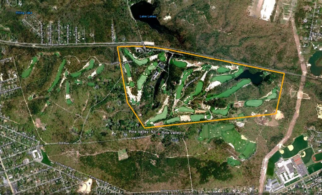
Following is an aerial that shows where the 184.31 acres are.  It is a tight squeeze for the modern course.  The early layouts apparently didn’t come as close to the southeast boundary as does the modern course.


________________________________________________________________________________________________________

On the 12th of May 1913, George A. Crump sold the exact same 184.31 acre piece of property to the Pine Valley Golf Club for $10.  No other valuable considerations are mentioned.

The exception for the right of way was also contained in this deed.

The condition and reservation from Crump’s deed is incorporated in this deed by reference to the Lumberton/Crump deed.  The details of the reservation are not articulated in this deed.

_____________________________________________________________________________________________________

Apart from the facts of this series of deeds and transactions, there are a number of implications to stories and histories about Pine Valley.

For one, the 1927 article in American Golfer by Thomas Uzzell that stated that:

Mr. Crump was the son of a British Consul to
this country who was a great huntsman and who
purchased the present property near the village of
Clementon, New Jersey, as a hunting preserve.
The son, inheriting the property, became interested
in golf and sensing the matchless appropriateness
of the land for a golf course devoted himself
wholeheartedly to producing the finest layout
money, devotion, and human ingenuity could
devise. He began the work in 1910 from his home
at Merchantsville near Philadelphia.
"

must be incorrect.


For another, the Camden Evening Courier article of 1927 by Jack Nunneville that stated that:

"Mr. Crump bought over 300 acres of ground years
ago for a hunting preserve and tramped it time and
again with his dogs, for he was a great huntsman.
"

in reference to the course location, must be incorrect.

Crump purchased the land for Pine Valley from the Lumberton Sand Company on October 30, 1912.  He did not inherit from his father.  He did not buy it years earlier. Nor was it part of a 300 acre property.  Nor, was it purchased as a hunting preserve.  Parts of the property for holes one through four were cleared within five months and Crump sold the property to Pine Valley Golf Club in just over 6 months.

« Last Edit: November 13, 2011, 10:21:44 PM by Bryan Izatt »

Joel_Stewart

  • Karma: +0/-0
Re: The Pine Valley Deeds
« Reply #1 on: November 07, 2011, 01:00:46 PM »
What are you going to do with the deeds?

Mark Chaplin

  • Karma: +0/-0
Re: The Pine Valley Deeds
« Reply #2 on: November 07, 2011, 01:38:39 PM »
I'll be interested to see if this has an impact on those who argue on everything and write in funny colours to "prove" their point. Could these deeds make a 100 page post arguing on the origins of the paper they are printed on?

Bryan - nice touch!
Cave Nil Vino

DMoriarty

  • Karma: +0/-0
Re: The Pine Valley Deeds
« Reply #3 on: November 07, 2011, 01:46:17 PM »
Thanks Bryan.

I am trying to make sense of your description of the "right of way."   You wrote:
   "The sale reserved and excepted therefrom a certain right of way to and from Sumner Station on the Narrow Gauge Railroad.  The right of way was 10 feet wide and started at the northwest corner of the property and followed the northern boundary of the property and then followed the railway boundary south to the station."
   As you know the RR runs on a NW-SE axis, so which is the "northern boundary" and which is the "northwest corner of the property?"  When you say the RR followed the RR boundary south to the station, I assume you mean from the corner near the 2nd tee to the RR station?    Does the deed provide a distance to the station or a more precise location from the station?  
   I am trying to get a understanding of where the "Sumner station" was located.  I know there was some sort of a RR related structure (a low slung structure) a bit to the northwest of the 17th tee (but south of the tracks) and I wonder if this was the so-called "Sumner Station?"

Thanks again.
_______________________________

Mark Chaplin,

Does your post serve any purpose whatsoever other than a passive-aggressive attempt to stir the pot?  

So far as I am concerned the deeds are just another piece in the puzzle, and while I agree with some of Bryan's list of "implications" I am not sure I agree totally with all of them.   For example, Bryan mentioned the golf course was "cleared almost immediately" but so far at least I don't see anything in the deeds relating to the timing of the clearing.  

But perhaps you could tell us what you think is the "impact" of deeds?
« Last Edit: November 07, 2011, 01:56:02 PM by DMoriarty »
Golf history can be quite interesting if you just let your favorite legends go and allow the truth to take you where it will.
--Tom MacWood (1958-2012)

DMoriarty

  • Karma: +0/-0
Re: The Pine Valley Deeds
« Reply #4 on: November 07, 2011, 02:01:17 PM »
Also Bryan,

I recall quite a lot of discussion about Pine Valley possibly having had to having to purchase additional acreage to fit the course, and quite a lot of discussion about the amount of land originally available at the east end of the property.   As you have presented it, the entire modern course fits.   

Regarding your drawing, did you actually plot the metes and bounds to come up with that?   If so, thanks for the effort.
Golf history can be quite interesting if you just let your favorite legends go and allow the truth to take you where it will.
--Tom MacWood (1958-2012)

Mark Chaplin

  • Karma: +0/-0
Re: The Pine Valley Deeds
« Reply #5 on: November 07, 2011, 03:10:46 PM »
Mr Moriarty - life is far too short.
Cave Nil Vino

DMoriarty

  • Karma: +0/-0
Re: The Pine Valley Deeds
« Reply #6 on: November 07, 2011, 03:25:18 PM »
Mr Moriarty - life is far too short.

I agree, which is why I find petty comments like yours above all the more perplexing.
Golf history can be quite interesting if you just let your favorite legends go and allow the truth to take you where it will.
--Tom MacWood (1958-2012)

JESII

  • Karma: +0/-0
Re: The Pine Valley Deeds
« Reply #7 on: November 07, 2011, 04:44:12 PM »
David,

All I recall along those lines was Pat throwing an unfounded theory against the wall to see if it would stick. The discovery story of 13 was his spark I think...

Jeff_Brauer

  • Karma: +0/-0
Re: The Pine Valley Deeds
« Reply #8 on: November 07, 2011, 05:20:26 PM »
Jim,

Only one unfounded theory?  I recall a few.

Bryan,

thanks for that research, or at least for passing on what those who don't post here any more have found.  I agree with others that it is just a piece of the puzzle for those truly interested.  It dispels the notion that he owned the property for hunting.  Somehow, someone translated an acre of property he inherited nearby into previous ownership of PV, showing as others have pointed out, that one article or recollection can sure be faulty for numerous reasons.

The ten foot narrow guage ROW is intriguing.  It actually sounds like it was just a siding running to the far side of the station, and any sand would have been carted to that siding for rail loading.  It seemingly ties in with TePaul's earlier description of where the site seemed to be mined, which would be determined by where the best pockets of sand were (naturally) and secondarily by the distance to the rail loading point.

Like David, it would be interesting to know if Sumner station moved around, and for that matter, why it was built in the first place.
Jeff Brauer, ASGCA Director of Outreach

Mike Nuzzo

  • Karma: +0/-0
Re: The Pine Valley Deeds
« Reply #9 on: November 07, 2011, 05:21:34 PM »
This is what I see:

One of the greatest golf courses in the world was restricted by arbitrary(?) property lines.
Would Pine Valley have been better if they could have purchased more land?

Cheers
Thinking of Bob, Rihc, Bill, George, Neil & Tiger.

Jeff_Brauer

  • Karma: +0/-0
Re: The Pine Valley Deeds
« Reply #10 on: November 07, 2011, 05:27:17 PM »
Mike,

IHMO, in an era when Merion could be done on 123 acres and NGLA was going to be 205 acres for golf and housing, Crump probably felt like he had secured enough land to do whatever he wanted.  Just a guess.  And, he had Colt consulting, and not Pete Dye, so there was little chance he would wander off unto the next property....
Jeff Brauer, ASGCA Director of Outreach

Mike Nuzzo

  • Karma: +0/-0
Re: The Pine Valley Deeds
« Reply #11 on: November 07, 2011, 05:47:06 PM »
Jeff
I've never studied a picture of Pine Valley with a property line before.
He obviously had "enough".

It looks constrained to me = they chose green, tee and turning points based on the property lines (on occasion) not the land forms.

Cheers
Thinking of Bob, Rihc, Bill, George, Neil & Tiger.

Bryan Izatt

  • Karma: +0/-0
Re: The Pine Valley Deeds
« Reply #12 on: November 07, 2011, 07:03:17 PM »
What are you going to do with the deeds?

The originals are where they always were, at the Camden County Clerk's Office. My copies will stay on my computer.

Bryan Izatt

  • Karma: +0/-0
Re: The Pine Valley Deeds
« Reply #13 on: November 07, 2011, 07:18:42 PM »
Thanks Bryan.

I am trying to make sense of your description of the "right of way."   You wrote:
   "The sale reserved and excepted therefrom a certain right of way to and from Sumner Station on the Narrow Gauge Railroad.  The right of way was 10 feet wide and started at the northwest corner of the property and followed the northern boundary of the property and then followed the railway boundary south to the station."
   As you know the RR runs on a NW-SE axis, so which is the "northern boundary" and which is the "northwest corner of the property?"  When you say the RR followed the RR boundary south to the station, I assume you mean from the corner near the 2nd tee to the RR station?  The right of way starts at the stone marked "JBS", which is the corner near the 6th green/7th tee and proceeds along the boundary that abuts what are now holes two and three to the RR.  Does the deed provide a distance to the station or a more precise location from the station?  No.  
   I am trying to get a understanding of where the "Sumner station" was located.  I know there was some sort of a RR related structure (a low slung structure) a bit to the northwest of the 17th tee (but south of the tracks) and I wonder if this was the so-called "Sumner Station?"

Thanks again.
_______________________________

.............................


Bryan Izatt

  • Karma: +0/-0
Re: The Pine Valley Deeds
« Reply #14 on: November 07, 2011, 07:25:08 PM »
Also Bryan,

I recall quite a lot of discussion about Pine Valley possibly having had to having to purchase additional acreage to fit the course, and quite a lot of discussion about the amount of land originally available at the east end of the property.   As you have presented it, the entire modern course fits.   

Regarding your drawing, did you actually plot the metes and bounds to come up with that?   If so, thanks for the effort.

The modern course barely fits, with arguably the back tees on 14 off the original property.  The Colt plan doesn't contemplate using the property down at that end near the boundary.  They did add the surrounding land fairly rapidly thereafter. 

Yes, I plotted the metes and bounds.


Patrick_Mucci

Re: The Pine Valley Deeds
« Reply #15 on: November 07, 2011, 10:08:10 PM »
Jim,

Only one unfounded theory?  I recall a few.

Since you claim to recall them, you should have no problem listing them.

Please do so without undue delay.


Patrick_Mucci

Re: The Pine Valley Deeds
« Reply #16 on: November 07, 2011, 10:56:06 PM »
What are you going to do with the deeds?

The originals are where they always were, at the Camden County Clerk's Office. My copies will stay on my computer.


David & Joel,

You know that TEPaul supplied this information to Bryan on the condition that he not share the documentation on GCA.com.

I shared the "stick routing" with Bryan, you and others, so that you could see and evaluate it for yourselves.

Evidently, Bryan doesn't share the same sense of disclosure in the interest of research, or he's under an informal "gag" order.

I'd prefer to see the deeds for myself, rather than rely upon third party references.
It wouldn't be the first time that deliberate misrepresentations have been presented as authentic.

Bryan Izatt

  • Karma: +0/-0
Re: The Pine Valley Deeds
« Reply #17 on: November 08, 2011, 01:48:19 AM »
Jeff,

You are making an erroneous assumption that I got these deeds from the one of those unnamed individuals who don't post here anymore.  Said persons do not share deeds with anyone else to post here.  The deeds don't require that much finding, they are publicly available at the Camden County Clerk's Office, with some searching.

Re the Sumner Station, the deeds obviously don't get into detail about where it is, or why, or when it was built.  You can infer that it was built before 1904, because the 1904 deed mentions it as an existing place.  For whatever it is worth, I don't think it likely that it was built specifically to serve local sand mining businesses. In 1904 the PV land was not owned by a sand company, nor were the surrounding properties.  Other than that, the deeds provide no insight as to why it would be there.  You can infer from the deeds that it was somewhere along the RR legs of what became the core PV property.

As to the ten foot ROW, there is no indication that it is a RR siding right of way.  The deed does allow that it is a  ROW that can be passed "on foot or with animals vehicles loads or otherwise".  No trains.  And, yes the deed is almost devoid of any punctuation.  Some commas would have been helpful.  ;)

Bryan Izatt

  • Karma: +0/-0
Re: The Pine Valley Deeds
« Reply #18 on: November 08, 2011, 02:07:46 AM »
Mike,

Within 5 years they acquired other properties, surrounding the 184.31 acres, that more than doubled the size of PV's holdings, but they stuck pretty much to routing the course on the core property.

Interesting thought that you see some routing decisions based on property lines rather than land forms.  Could you give some examples. 

If you think the full 184.31 acres was constricted, it is curious that Colt did a plan in 1913  that didn't even use all of the 184 acres.  Please note that although the following plan is supposedly drawn to scale, and the property has the same shape as the deeds, the actual lengths of the legs on this picture of the plan are somewhat off the deed measurements.


Bryan Izatt

  • Karma: +0/-0
Re: The Pine Valley Deeds
« Reply #19 on: November 08, 2011, 02:20:21 AM »
Patrick,

You are so full of it!  Do you not remember that Tom refused to give me the Merion deeds and I had to find them myself through other means?  Why would he give me the PV ones?  A "gag" order, now, that's just laughable.

For the record, the deeds are not from Tom.   

I'm insulted that you think that I would misrepresent the deeds.   >:(

Did you ask if I was going to post the actual deeds before you maligned my character?   >:(


What are you going to do with the deeds?


The originals are where they always were, at the Camden County Clerk's Office. My copies will stay on my computer.


David & Joel,

You know that TEPaul supplied this information to Bryan on the condition that he not share the documentation on GCA.com.

I shared the "stick routing" with Bryan, you and others, so that you could see and evaluate it for yourselves.

Evidently, Bryan doesn't share the same sense of disclosure in the interest of research, or he's under an informal "gag" order.

I'd prefer to see the deeds for myself, rather than rely upon third party references.
It wouldn't be the first time that deliberate misrepresentations have been presented as authentic.


Bryan Izatt

  • Karma: +0/-0
Re: The Pine Valley Deeds
« Reply #20 on: November 08, 2011, 02:22:50 AM »
David,

Re the train station - the stick routing topo and the Cold plan (just above) both mark where the station is, alongside the beginning of the 1st fairway.  Is that not sufficient proof for you of their location? 

Bryan Izatt

  • Karma: +0/-0
Re: The Pine Valley Deeds
« Reply #21 on: November 08, 2011, 03:12:55 AM »
On November 7, 1914 Pine Valley Golf Club bought from Virginia E. Ireland for $1, “free and uninterrupted use liberty and privilege of and passage in and along a right of way thirty feet wide in and along the present road extending from the road leading from Clementon to New Freedom and across the lands of said party of the first part to the railroad station located on the Atlantic City Railroad and known as Sumner Station

There are no metes and bounds provided for the existing road.

The use was “forever” regardless of how the road might change.

The use was for “ingress egress and regress” for Pine Valley and its “members theirbfriends (sic) and their servants”.  They obtained a right to pass on “foot and with animals loads and vehicles”.

The Clementon to New Freedom road is northeast of the RR tracks on the opposite side to the PV property.  Presumably PV bought this use of the right of way to provide an alternate to the train as a way to access the club.  My guess would be that the "present road" in question is the one, shown in blue, that skirts Lake Lekau on the 1898 topo below.  On today’s map, the Clementon to New Freedom road is likely County Rd 691 and the road in question is probably Old Mill Rd.

This would place Sumner Station in the same place as depicted in the stick routing topo and the Colt plan.


« Last Edit: November 08, 2011, 03:15:55 AM by Bryan Izatt »

Mike Nuzzo

  • Karma: +0/-0
Re: The Pine Valley Deeds
« Reply #22 on: November 08, 2011, 10:10:23 AM »
Mike,

Within 5 years they acquired other properties, surrounding the 184.31 acres, that more than doubled the size of PV's holdings, but they stuck pretty much to routing the course on the core property.

Interesting thought that you see some routing decisions based on property lines rather than land forms.  Could you give some examples.  


Thank you Bryan
The routing was totally based/constrained on property lines, I can't tell if the land forms dictated the boundary lines or the golf.
Maybe that made the course better in some instances - like #2 - maybe less so in other locations.
Forcing the team to focus on what they had could have helped too.
Cheers


« Last Edit: November 08, 2011, 10:40:37 AM by Mike Nuzzo »
Thinking of Bob, Rihc, Bill, George, Neil & Tiger.

Jeff_Brauer

  • Karma: +0/-0
Re: The Pine Valley Deeds
« Reply #23 on: November 08, 2011, 10:24:06 AM »
Bryan,

My apologies for assuming it was TePaul, who also called last night to tell me you found it on your own.  IMHO, if Pat wants to see the original deeds himself, he ought to go find them like you do, rather than basically call your integrity into question.

As always, as a taker of info from these threads, I appreciate the hard work others put in.  Its always fascinating to learn these little details, even as many are NOT signifgant to the actual design history of PV.  Who knows when someone like David is going to inform us about early century camer tech as a bonus to our regularly scheduled discussions.  (Being serious there, not snarky, as that kind of stuff really does fascinate me.)

Pat,

Also need to apolgize to you for a snarky comment, which I shouldn't have made.....even if true.  I don't think this thread needs to go that direction.  But, for the record, you keep asking me to list the examples of you throwing poo against the wall on the other thread, as if you haven't asked and I haven't answered at least a few times before.  I have and won't do it again.
Jeff Brauer, ASGCA Director of Outreach

Bryan Izatt

  • Karma: +0/-0
Re: The Pine Valley Deeds
« Reply #24 on: November 08, 2011, 11:55:57 AM »
Mike,

This property was a distinct bounded lot.  It was not part of a bigger holding, unlike NGLA or Merion where the architect had the opportunity to select their boundaries from within a larger tract.  In that context, maybe the routing was driven as much by boundaries as land forms. 

Mike,

Within 5 years they acquired other properties, surrounding the 184.31 acres, that more than doubled the size of PV's holdings, but they stuck pretty much to routing the course on the core property.

Interesting thought that you see some routing decisions based on property lines rather than land forms.  Could you give some examples.  


Thank you Bryan
The routing was totally based/constrained on property lines, I can't tell if the land forms dictated the boundary lines or the golf.
Maybe that made the course better in some instances - like #2 - maybe less so in other locations.
Forcing the team to focus on what they had could have helped too.
Cheers


Tags:
Tags:

An Error Has Occurred!

Call to undefined function theme_linktree()
Back